
Make a donation
Gear up for your next adventure:
As an Amazon Associate, this site earns from qualifying purchases at no extra cost to you.
Puncak Jaya topographic map
Click on the map to display elevation.
Make a donation
Gear up for your next adventure:
As an Amazon Associate, this site earns from qualifying purchases at no extra cost to you.
Puncak Jaya
Puncak Jaya (Indonesian: [ˈpuntʃak ˈdʒaja]; literally "Glorious Peak", Amungme: Nemangkawi Ninggok) or Carstensz Pyramid (/ˈkɑːrstəns/, Indonesian: Piramida Carstensz, Dutch: Carstenszpiramide) on the island of New Guinea, with an elevation of 4,884 m (16,024 ft), is the highest mountain peak of an island on Earth, and the highest peak in Indonesia. As the western half of New Guinea is politically associated with Southeast Asia (on account of being presently controlled by Indonesia), Puncak Jaya can be considered the 8th highest mountain of this region. However, as the whole island of New Guinea is biogeographically part of the Australian continent, the peak can also be considered the highest of all Oceania, and thus one of the Seven Summits.
Make a donation
Gear up for your next adventure:
As an Amazon Associate, this site earns from qualifying purchases at no extra cost to you.
About this map
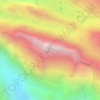
Name: Puncak Jaya topographic map, elevation, terrain.
Average elevation: 14,012 ft
Minimum elevation: 11,745 ft
Maximum elevation: 15,810 ft
Make a donation
Gear up for your next adventure:
As an Amazon Associate, this site earns from qualifying purchases at no extra cost to you.
Other topographic maps
Click on a map to view its topography, its elevation and its terrain.