
Make a donation
Gear up for your next adventure:
As an Amazon Associate, this site earns from qualifying purchases at no extra cost to you.
Valpiana topographic map
Click on the map to display elevation.
Make a donation
Gear up for your next adventure:
As an Amazon Associate, this site earns from qualifying purchases at no extra cost to you.
About this map
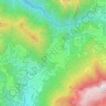
Name: Valpiana topographic map, elevation, terrain.
Average elevation: 3,629 ft
Minimum elevation: 2,083 ft
Maximum elevation: 6,299 ft
Make a donation
Gear up for your next adventure:
As an Amazon Associate, this site earns from qualifying purchases at no extra cost to you.
Other topographic maps
Click on a map to view its topography, its elevation and its terrain.
Gorno
The municipality is located in the lower part of the Val del Riso, a valley that starts east of the Colle di Zambla and descends opening westward, flowing into the wider Val Seriana. The territory draws an irregular geometric profile, with very pronounced elevation variations. The altitude of the municipal…
Average elevation: 3,176 ft
Make a donation
Gear up for your next adventure:
As an Amazon Associate, this site earns from qualifying purchases at no extra cost to you.