
Make a donation
Gear up for your next adventure:
As an Amazon Associate, this site earns from qualifying purchases at no extra cost to you.
Tignes topographic map
Click on the map to display elevation.
Make a donation
Gear up for your next adventure:
As an Amazon Associate, this site earns from qualifying purchases at no extra cost to you.
Tignes
The terrain of valley lends itself to more challenging skiing, with advanced skiers often opting for the resort as their preferred ski area. The town has however strived to improve its appeal to beginner and intermediate skiers with the introduction of easier runs lower down in the valley towards Tignes-Les-Brévières and upgrading existing chairlifts and installing new ones with smaller elevation gains.
Make a donation
Gear up for your next adventure:
As an Amazon Associate, this site earns from qualifying purchases at no extra cost to you.
About this map
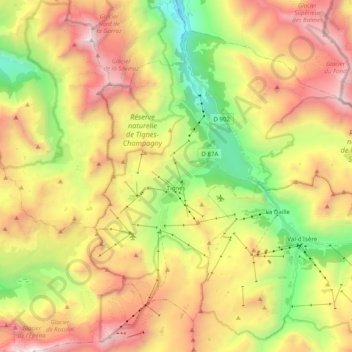
Name: Tignes topographic map, elevation, terrain.
Average elevation: 8,268 ft
Minimum elevation: 4,551 ft
Maximum elevation: 12,503 ft
Make a donation
Gear up for your next adventure:
As an Amazon Associate, this site earns from qualifying purchases at no extra cost to you.
Other topographic maps
Click on a map to view its topography, its elevation and its terrain.