
Make a donation
Gear up for your next adventure:
As an Amazon Associate, this site earns from qualifying purchases at no extra cost to you.
Nieder-Olm topographic map
Click on the map to display elevation.
Make a donation
Gear up for your next adventure:
As an Amazon Associate, this site earns from qualifying purchases at no extra cost to you.
Nieder-Olm
Nieder-Olm liegt am östlichen Ufer der Selz im nördlichen Teil des Rheinhessischen Hügellands, dem Mainzer Becken. Die durchschnittliche Höhe der Stadt beträgt etwa 150 Meter über Normalnull. Die höchste Erhebung der Gemarkung ist der „Mühlberg“ mit 243 m ü. NHN, er liegt im Nordosten zwischen Nieder-Olm und Mainz-Ebersheim. Der Mühlbach mündet an der Eulenmühle in die Selz; unterhalb der Stadt fließt von rechts der Haybach zu.
Make a donation
Gear up for your next adventure:
As an Amazon Associate, this site earns from qualifying purchases at no extra cost to you.
About this map
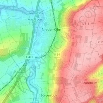
Name: Nieder-Olm topographic map, elevation, terrain.
Average elevation: 571 ft
Minimum elevation: 361 ft
Maximum elevation: 817 ft
Make a donation
Gear up for your next adventure:
As an Amazon Associate, this site earns from qualifying purchases at no extra cost to you.
Other topographic maps
Click on a map to view its topography, its elevation and its terrain.
Henschhausen
Deutschland > Rheinland-Pfalz > Landkreis Mainz-Bingen > Bacharach
Henschhausen liegt in knapp 300 Meter Höhe auf der linken Hochfläche des Oberen Mittelrheintales am östlichen Ende des Hunsrück.
Average elevation: 801 ft
Uhlerborn
Deutschland > Rheinland-Pfalz > Landkreis Mainz-Bingen > Ingelheim am Rhein
Average elevation: 397 ft
NSG Wiesen am Hirtenborn
Deutschland > Rheinland-Pfalz > Landkreis Mainz-Bingen > Oberdiebach
Average elevation: 1,467 ft
Make a donation
Gear up for your next adventure:
As an Amazon Associate, this site earns from qualifying purchases at no extra cost to you.
Neurath
Deutschland > Rheinland-Pfalz > Landkreis Mainz-Bingen > Bacharach
Neurath liegt südwestlich der Burg Stahleck und am Fuße des Rabenkopfes (395 m ü. NHN) in 240 m Höhe auf der linken Hochfläche des Oberen Mittelrheintales am östlichen Ende des Hunsrück. Der Ort ist mit dem ein Kilometer nördlich am Rheinufer gelegenen Hauptort durch die Kreisstraße 24…
Average elevation: 771 ft
Burg Sooneck
Deutschland > Rheinland-Pfalz > Landkreis Mainz-Bingen > Niederheimbach
Average elevation: 840 ft
Nauheim
Deutschland > Rheinland-Pfalz > Landkreis Mainz-Bingen > Bacharach > Neurath
Average elevation: 823 ft