
Brandemburgo topographic map
Interactive map
Click on the map to display elevation.
About this map
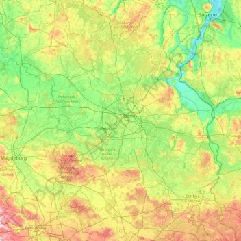
Name: Brandemburgo topographic map, elevation, terrain.
Location: Brandemburgo, Alemania (51.35906 11.26623 53.55909 14.76582)
Average elevation: 223 ft
Minimum elevation: -7 ft
Maximum elevation: 1,030 ft
Other topographic maps
Click on a map to view its topography, its elevation and its terrain.
Cottbus - Chóśebuz
Alemania > Brandemburgo > Cottbus - Chóśebuz
Cottbus - Chóśebuz, Brandemburgo, Alemania
Average elevation: 226 ft
G 29
Alemania > Brandemburgo > Kolkwitz
G 29, Kolkwitz, Spree-Neiße, Brandemburgo, Alemania
Average elevation: 217 ft
Gröden
Alemania > Brandemburgo > Gröden
Gröden, Schradenland, Elbe-Elster, Brandemburgo, Alemania
Average elevation: 351 ft
Wallitz
Alemania > Brandemburgo > Rheinsberg
Wallitz, Rheinsberg, Ostprignitz-Ruppin, Brandemburgo, 18837, Alemania
Average elevation: 276 ft
D 45
Alemania > Brandemburgo > Neuhausen/Spree
D 45, Neuhausen/Spree, Spree-Neiße, Brandemburgo, Alemania
Average elevation: 325 ft