
Make a donation
Gear up for your next adventure:
As an Amazon Associate, this site earns from qualifying purchases at no extra cost to you.
Real de Catorce topographic map
Click on the map to display elevation.
Make a donation
Gear up for your next adventure:
As an Amazon Associate, this site earns from qualifying purchases at no extra cost to you.
Real de Catorce
Although in the southern range of the Chihuahuan desert, due to its elevation, Real can be very cool at night. Although days, particularly in summer, can be very hot, it is advised to always bring a jacket, even in summer.
Make a donation
Gear up for your next adventure:
As an Amazon Associate, this site earns from qualifying purchases at no extra cost to you.
About this map
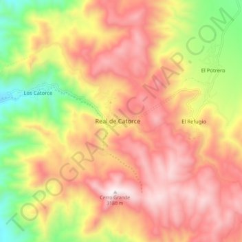
Name: Real de Catorce topographic map, elevation, terrain.
Location: Real de Catorce, Catorce, San Luis Potosí, Mexico (23.65022 -100.92617 23.73022 -100.84617)
Average elevation: 8,763 ft
Minimum elevation: 6,719 ft
Maximum elevation: 10,387 ft
Make a donation
Gear up for your next adventure:
As an Amazon Associate, this site earns from qualifying purchases at no extra cost to you.