
Make a donation
Gear up for your next adventure:
As an Amazon Associate, this site earns from qualifying purchases at no extra cost to you.
Ola topographic map
Click on the map to display elevation.
Make a donation
Gear up for your next adventure:
As an Amazon Associate, this site earns from qualifying purchases at no extra cost to you.
About this map
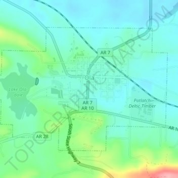
Name: Ola topographic map, elevation, terrain.
Location: Ola, Yell County, Arkansas, 72853, United States (35.02117 -93.24165 35.03990 -93.20876)
Average elevation: 387 ft
Minimum elevation: 295 ft
Maximum elevation: 692 ft
Yell County trails, hiking, mountain biking, running and outdoor activities
Make a donation
Gear up for your next adventure:
As an Amazon Associate, this site earns from qualifying purchases at no extra cost to you.
Other topographic maps
Click on a map to view its topography, its elevation and its terrain.
Petit Jean River State Wildlife Management Area
United States > Arkansas > Yell County
Average elevation: 315 ft
Make a donation
Gear up for your next adventure:
As an Amazon Associate, this site earns from qualifying purchases at no extra cost to you.