Geolocate

Potenza topographic map

Click on the map to display elevation.

About this map

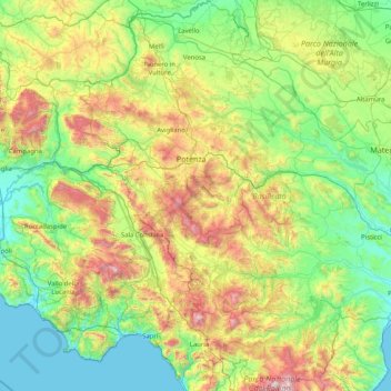
Name: Potenza topographic map, elevation, terrain.

Location: Potenza, Basilicata, Italy (39.89581 15.33497 41.13954 16.39957)

Average elevation: 1,713 ft

Minimum elevation: 0 ft

Maximum elevation: 7,172 ft

Other topographic maps

Click on a map to view its topography, its elevation and its terrain.

Pollino National Park

Italy > Basilicata

Average elevation: 1,955 ft

Tempa Parese

Italy > Basilicata > Matera > Stigliano

Average elevation: 1,394 ft

Torricelli

Italy > Basilicata > Matera > Ferrandina

Average elevation: 925 ft

Pianelle

Italy > Basilicata > Matera > Montescaglioso > Pianelle

Average elevation: 512 ft

Agri

Italy > Basilicata > Potenza > San Martino d'Agri

Average elevation: 1,611 ft

Gear up for your next adventure:

📌Outdoor GPS Map App - Apps and devices for digital topographic navigation
🔦Powerful Headlamps - Ultra-bright hands-free lighting for night navigation
🚑Emergency Bivvies - Heat-reflective sleeping bags for survival situations
📚USA Hiking Guide Books - Top trail guides and map books
🧣Hiking Neck Gaiter - Multi‑use neck protection for outdoor weather

As an Amazon Associate, this site earns from qualifying purchases at no extra cost to you.