
Hessigheim topographic map
Click on the map to display elevation.
Hessigheim
The municipality (Gemeinde) of Hessigheim is located in the district of Ludwigsburg, in Baden-Württemberg, one of the 16 States of the Federal Republic of Germany. Hessigheim is physically located in the basin of [de] the Neckar. Elevation above sea level in the municipal area ranges from a high of 306 meters (1,004 ft) Normalnull (NN) to a low of 173 meters (568 ft) NN.
About this map
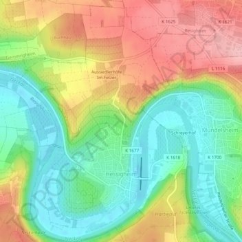
Name: Hessigheim topographic map, elevation, terrain.
Average elevation: 791 ft
Minimum elevation: 574 ft
Maximum elevation: 1,076 ft
Other topographic maps
Click on a map to view its topography, its elevation and its terrain.
Relling
Germany > Baden-Württemberg > Landkreis Ludwigsburg > Freiberg am Neckar
Average elevation: 843 ft