
Mattoon topographic map
Click on the map to display elevation.
Mattoon
One of the main factors determining the settlement of Mattoon and Coles County in general was the topography. Coles County straddled a timberline in the southern half and prairie in the north. The forested areas were primarily fed by two major rivers: the Embarras River in the east and the Kaskaskia in the west. The prairie, known as the "Grand Prairie", was generally wet and swampy. An early historian described the geography.
About this map
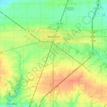
Name: Mattoon topographic map, elevation, terrain.
Location: Mattoon, Coles County, Illinois, 61938, United States (39.41045 -88.41922 39.52085 -88.26652)
Average elevation: 722 ft
Minimum elevation: 659 ft
Maximum elevation: 794 ft
Coles County trails, hiking, mountain biking, running and outdoor activities
Other topographic maps
Click on a map to view its topography, its elevation and its terrain.