
Thank you for supporting this site ❤️
Make a donation
Make a donation
Gear up for your next adventure:
As an Amazon Associate, this site earns from qualifying purchases at no extra cost to you.
Lapai topographic map
Click on the map to display elevation.
Thank you for supporting this site ❤️
Make a donation
Make a donation
Gear up for your next adventure:
As an Amazon Associate, this site earns from qualifying purchases at no extra cost to you.
About this map
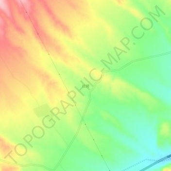
Name: Lapai topographic map, elevation, terrain.
Location: Lapai, Jingtai County, Baiyin City, Gansu, China (36.93118 103.75516 36.97118 103.79516)
Average elevation: 7,694 ft
Minimum elevation: 7,418 ft
Maximum elevation: 8,005 ft
Thank you for supporting this site ❤️
Make a donation
Make a donation
Gear up for your next adventure:
As an Amazon Associate, this site earns from qualifying purchases at no extra cost to you.