Geolocate

Kalbajar topographic map

Click on the map to display elevation.

About this map

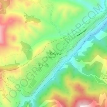
Name: Kalbajar topographic map, elevation, terrain.

Location: Kalbajar, Kalbajar District, East Zangezur, Azerbaijan (40.09307 46.01578 40.12001 46.05946)

Average elevation: 5,377 ft

Minimum elevation: 4,560 ft

Maximum elevation: 6,572 ft

Other topographic maps

Click on a map to view its topography, its elevation and its terrain.

Malibay

Azerbaijan > East Zangezur

Average elevation: 3,983 ft

Lachin

Azerbaijan > East Zangezur

Average elevation: 5,656 ft

Zabukh

Azerbaijan > East Zangezur

Average elevation: 3,173 ft

Hacılar

Azerbaijan > East Zangezur

Average elevation: 4,751 ft

Gear up for your next adventure:

🗺️NatGeo Topo Maps - High-quality waterproof printed topographic maps of US Parks
📚Navigation Handbooks - Master the art of reading topographic maps and using a compass
🪶Survival Guide Book - Expert advice for emergency preparedness
🧭Orienteering Set - Complete compass and map reading kit
GPS Sports Watch - GPS watch for running, hiking and training

As an Amazon Associate, this site earns from qualifying purchases at no extra cost to you.