Geolocate

Steingaden topographic map

Click on the map to display elevation.

About this map

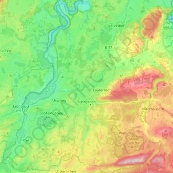
Name: Steingaden topographic map, elevation, terrain.

Location: Steingaden, Steingaden (VGem), Landkreis Weilheim-Schongau, Bavaria, 86989, Germany (47.65504 10.80270 47.77174 10.91947)

Average elevation: 2,618 ft

Minimum elevation: 2,274 ft

Maximum elevation: 3,310 ft

Other topographic maps

Click on a map to view its topography, its elevation and its terrain.

Dessau

Germany > Bavaria > Landkreis Weilheim-Schongau > Burggen

Average elevation: 2,457 ft

Erbenschwang

Germany > Bavaria > Landkreis Weilheim-Schongau

Average elevation: 2,552 ft

Tauting

Germany > Bavaria > Landkreis Weilheim-Schongau

Average elevation: 2,133 ft

Fischen

Germany > Bavaria > Landkreis Weilheim-Schongau

Average elevation: 1,893 ft

Gear up for your next adventure:

🪓Survival Multi‑Tool - Versatile tool for camp and trail tasks
👟Men's Trail Runners - Lightweight footwear for fast-paced exploration and light hiking
📶Vehicle Signal Boosters - Improve reception in rural areas while driving to trailheads
🧺Microfiber Travel Towels - Compact and fast-drying towels for trail use
🥩Freeze-Dried Meals - Nutritious and lightweight food for remote expeditions

As an Amazon Associate, this site earns from qualifying purchases at no extra cost to you.