Geolocate

Broglina topographic map

Click on the map to display elevation.

About this map

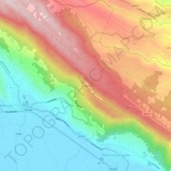
Name: Broglina topographic map, elevation, terrain.

Location: Broglina, Magnano, Biella, Piemonte, 13884, Italia (45.45548 7.94868 45.49548 7.98868)

Average elevation: 1,421 ft

Minimum elevation: 761 ft

Maximum elevation: 2,205 ft

Gear up for your next adventure:

🪶Multi‑Purpose Knife - Useful blade for camp and trail
🦟Ultrasonic Repellers - Create a bug-free zone at your camp or rest stop
🌡️Portable Weather Meter - Track weather conditions on the trail
🦺Reflective Outdoor Gear - Safety gear for low‑light conditions
⛑️Personal Locator Beacon - Safety beacon for emergencies

As an Amazon Associate, this site earns from qualifying purchases at no extra cost to you.