Geolocate

Can-avid topographic map

Click on the map to display elevation.

About this map

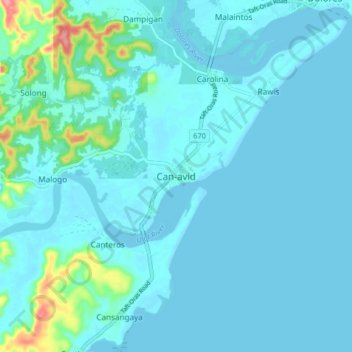
Name: Can-avid topographic map, elevation, terrain.

Location: Can-avid, Eastern Samar, Eastern Visayas, 6806, Philippines (11.95689 125.40852 12.03689 125.48852)

Average elevation: 33 ft

Minimum elevation: -7 ft

Maximum elevation: 299 ft

Other topographic maps

Click on a map to view its topography, its elevation and its terrain.

Borongan City

Philippines > Eastern Samar

Average elevation: 36 ft

Jipapad

Philippines > Eastern Samar

Average elevation: 361 ft

Hilabaan

Philippines > Eastern Samar

Average elevation: 3 ft

Tikling

Philippines > Eastern Samar

Average elevation: 0 ft

Homonhon Island

Philippines > Eastern Samar > Habag

Average elevation: 89 ft

Suluan Island

Philippines > Eastern Samar > Suluan

Average elevation: 39 ft

Manicani Island

Philippines > Eastern Samar > Banaag

Average elevation: 59 ft

Homonhon Island

Philippines > Eastern Samar > Culasi

Average elevation: 89 ft

Leleboon Island

Philippines > Eastern Samar > Sulangan

Average elevation: 13 ft

Oras

Philippines > Eastern Samar > Jipapad

Average elevation: 121 ft

Calicoan Island

Philippines > Eastern Samar > Ngolos

Average elevation: 13 ft

Homonhon Island

Philippines > Eastern Samar > Culasi

Average elevation: 89 ft

Gear up for your next adventure:

🧷Carabiner Set - Durable clips for gear attachment
🧭Outdoor Navigation Book - Learn advanced navigation skills
📷Action Cameras - Rugged cameras to document your journeys across rugged terrain
🦺Reflective Outdoor Gear - Safety gear for low‑light conditions
🔋Rechargeable Batteries - Power up your outdoor devices

As an Amazon Associate, this site earns from qualifying purchases at no extra cost to you.