Geolocate

Grogol topographic map

Click on the map to display elevation.

👉 Easily get elevation data in JSON, GeoTIFF and KML formats using Elevation API
Thank you for supporting this site ❤️
Make a donation

About this map

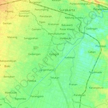
Name: Grogol topographic map, elevation, terrain.

Location: Grogol, Sukoharjo, Central Java, Java, 57552, Indonesia (-7.64203 110.77863 -7.56203 110.85863)

Average elevation: 308 ft

Minimum elevation: 269 ft

Maximum elevation: 348 ft

Other topographic maps

Click on a map to view its topography, its elevation and its terrain.

Bulu

Indonesia > Central Java > Sukoharjo

Average elevation: 413 ft

Puron

Indonesia > Central Java > Sukoharjo

Average elevation: 420 ft

Lapangan Makamhaji

Indonesia > Central Java > Sukoharjo > Gentan > Kuyudan

Average elevation: 341 ft

Waduk Mulur

Indonesia > Central Java > Sukoharjo > Bendosari

Average elevation: 374 ft

Karangasem

Indonesia > Central Java > Sukoharjo > Karangasem

Average elevation: 377 ft

Gear up for your next adventure:

👖Convertible Hiking Pants - Versatile zip-off pants for changing altitudes and temperatures
🎒Outdoor Daypacks - Lightweight backpacks designed for carrying maps and essential gear
🥤Water Filter Bottle - All‑in‑one filter bottle for safe hydration
🎁Geography Themed Gifts - Unique gift ideas for map lovers and geography enthusiasts
Camping Coffee Makers - Enjoy premium coffee at the summit or campsite

As an Amazon Associate, this site earns from qualifying purchases at no extra cost to you.