
Make a donation
Gear up for your next adventure:
As an Amazon Associate, this site earns from qualifying purchases at no extra cost to you.
Bergland Township topographic map
Click on the map to display elevation.
Make a donation
Gear up for your next adventure:
As an Amazon Associate, this site earns from qualifying purchases at no extra cost to you.
About this map
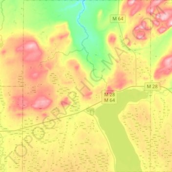
Name: Bergland Township topographic map, elevation, terrain.
Average elevation: 1,335 ft
Minimum elevation: 971 ft
Maximum elevation: 1,762 ft
Make a donation
Gear up for your next adventure:
As an Amazon Associate, this site earns from qualifying purchases at no extra cost to you.
Other topographic maps
Click on a map to view its topography, its elevation and its terrain.
Merriweather
United States > Michigan > Ontonagon County > Bergland Township
Average elevation: 1,339 ft
Sucker Creek
United States > Michigan > Ontonagon County > McMillan Township
Average elevation: 1,191 ft
Make a donation
Gear up for your next adventure:
As an Amazon Associate, this site earns from qualifying purchases at no extra cost to you.
Matchwood
United States > Michigan > Ontonagon County > Matchwood Township
Average elevation: 1,230 ft