
Mayhill topographic map
Interactive map
Click on the map to display elevation.
About this map
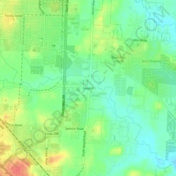
Name: Mayhill topographic map, elevation, terrain.
Location: Mayhill, Denton, Denton County, Texas, 76208, United States (33.18429 -97.10446 33.22429 -97.06446)
Average elevation: 600 ft
Minimum elevation: 531 ft
Maximum elevation: 702 ft
Other topographic maps
Click on a map to view its topography, its elevation and its terrain.
Cooper Creek
United States > Texas > Denton County > Denton
Cooper Creek, Denton, Denton County, Texas, 76298, United States
Average elevation: 604 ft
Mingo
United States > Texas > Denton County > Denton
Mingo, Denton, Denton County, Texas, 76298, United States
Average elevation: 564 ft
Green Valley
United States > Texas > Denton County > Denton
Green Valley, Denton, Denton County, Texas, United States
Average elevation: 591 ft
North Pointe Park
United States > Texas > Denton County > Denton
North Pointe Park, Denton, Denton County, Texas, 76201, United States
Average elevation: 689 ft
South Lakes Park
United States > Texas > Denton County > Denton
South Lakes Park, Denton, Denton County, Texas, 76205, United States
Average elevation: 659 ft