
Thank you for supporting this site ❤️
Make a donation
Make a donation
Gear up for your next adventure:
As an Amazon Associate, this site earns from qualifying purchases at no extra cost to you.
Olmedo topographic map
Click on the map to display elevation.
Thank you for supporting this site ❤️
Make a donation
Make a donation
Gear up for your next adventure:
As an Amazon Associate, this site earns from qualifying purchases at no extra cost to you.
About this map
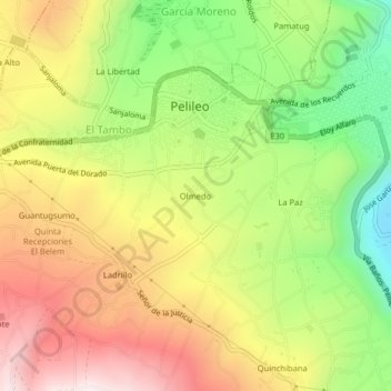
Name: Olmedo topographic map, elevation, terrain.
Location: Olmedo, El Tambo, Pelileo, Tungurahua, 180701, Ecuador (-1.35875 -78.56501 -1.31875 -78.52501)
Average elevation: 8,770 ft
Minimum elevation: 7,507 ft
Maximum elevation: 10,033 ft
Thank you for supporting this site ❤️
Make a donation
Make a donation
Gear up for your next adventure:
As an Amazon Associate, this site earns from qualifying purchases at no extra cost to you.