Geolocate

Saltara topographic map

Click on the map to display elevation.

About this map
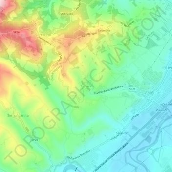
Name: Saltara topographic map, elevation, terrain.

Location: Saltara, Colli al Metauro, Pesaro e Urbino, Marche, 61036, Italia (43.73366 12.87726 43.77366 12.91726)

Average elevation: 476 ft

Minimum elevation: 138 ft

Maximum elevation: 1,152 ft

Other topographic maps

Click on a map to view its topography, its elevation and its terrain.

Montelabbate

Italia > Marche > Pesaro e Urbino

L'altitudine è compresa tra i 50 e i 300 m s.l.m.

Average elevation: 430 ft

Tavullia

Italia > Marche > Pesaro e Urbino

Average elevation: 312 ft

Monte Cerignone

Italia > Marche > Pesaro e Urbino

Average elevation: 1,883 ft

Mombaroccio

Italia > Marche > Pesaro e Urbino

Average elevation: 591 ft

Lunano

Italia > Marche > Pesaro e Urbino

Average elevation: 1,309 ft

Petriano

Italia > Marche > Pesaro e Urbino

Average elevation: 722 ft

Mondavio

Italia > Marche > Pesaro e Urbino

Average elevation: 548 ft

Gear up for your next adventure:

🥤Water Filter Bottle - All‑in‑one filter bottle for safe hydration
👓Polarized Sunglasses - Outdoor sunglasses for glare reduction
🛡️Bear Spray Outdoor - Protection in bear country hikes
🧢Outdoor Hiking Hat - Sun protection hat for outdoor explorers
🍳Camping Cook Set - Complete cookware for outdoor meals

As an Amazon Associate, this site earns from qualifying purchases at no extra cost to you.