Geolocate

Johnson City topographic map

Click on the map to display elevation.

About this map

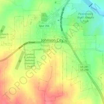
Name: Johnson City topographic map, elevation, terrain.

Location: Johnson City, Blanco County, Texas, 78636, United States (30.25946 -98.42619 30.28805 -98.39101)

Average elevation: 1,230 ft

Minimum elevation: 1,102 ft

Maximum elevation: 1,352 ft

Blanco County trails, hiking, mountain biking, running and outdoor activities

Other topographic maps

Click on a map to view its topography, its elevation and its terrain.

Cypress Mill

United States > Texas > Blanco County

Average elevation: 1,043 ft

Twin Sisters

United States > Texas > Blanco County

Average elevation: 1,493 ft

Round Mountain

United States > Texas > Blanco County

Average elevation: 1,312 ft

Gear up for your next adventure:

🏫Relief Map Kits - Hands-on tools for teaching landforms and elevation
🦶Carbon Trekking Poles - Reduce knee impact on steep descents with ultra-light poles
📡GPS Antenna Upgrade - Enhance GPS reception in remote terrain
🗺️Topographic Maps - Detailed topo maps for hiking, exploring and outdoor navigation
🩳Quick‑Dry Hiking Shorts - Comfortable and quick‑dry shorts for summer hiking

As an Amazon Associate, this site earns from qualifying purchases at no extra cost to you.