Geolocate

Logbara topographic map

Click on the map to display elevation.

About this map

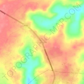
Name: Logbara topographic map, elevation, terrain.

Location: Logbara, Obafemi Owode, Ogun State, Nigeria (6.89667 3.54667 6.93667 3.58667)

Average elevation: 338 ft

Minimum elevation: 180 ft

Maximum elevation: 430 ft

Gear up for your next adventure:

🔥Camping Stove - Portable stove for camping and backcountry cooking
🪵Folding Camp Saw - Compact saw for wood and campsite work
🏔️Mountain Trail Maps - High‑detail maps for popular peaks
🌐World Map Poster - Decorative world maps with topographic info
🦶Carbon Trekking Poles - Reduce knee impact on steep descents with ultra-light poles

As an Amazon Associate, this site earns from qualifying purchases at no extra cost to you.