
Thank you for supporting this site ❤️
Make a donation
Make a donation
Gear up for your next adventure:
As an Amazon Associate, this site earns from qualifying purchases at no extra cost to you.
Chamisero topographic map
Click on the map to display elevation.
Thank you for supporting this site ❤️
Make a donation
Make a donation
Gear up for your next adventure:
As an Amazon Associate, this site earns from qualifying purchases at no extra cost to you.
About this map
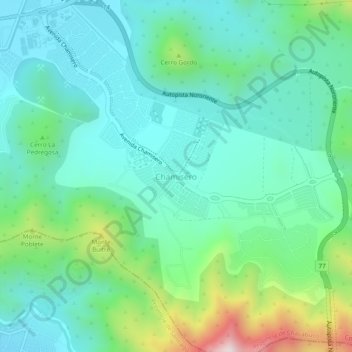
Name: Chamisero topographic map, elevation, terrain.
Average elevation: 2,293 ft
Minimum elevation: 1,722 ft
Maximum elevation: 4,108 ft
Thank you for supporting this site ❤️
Make a donation
Make a donation
Gear up for your next adventure:
As an Amazon Associate, this site earns from qualifying purchases at no extra cost to you.
Other topographic maps
Click on a map to view its topography, its elevation and its terrain.
Laguna Piedra Roja
Chile > Región Metropolitana de Santiago > Provincia de Chacabuco > Colina > Chicureo
Average elevation: 2,054 ft
Canal El Carmen
Chile > Región Metropolitana de Santiago > Provincia de Chacabuco > Colina > Los Jardines de Colina
Average elevation: 1,749 ft