Geolocate

Handwara topographic map

Click on the map to display elevation.

Handwara

Handwara is located at 34°24′N 74°17′E / 34.40°N 74.28°E / 34.40; 74.28 at an average elevation of 1,582 metres (5,190 feet) above sea level.

Wikipedia (CC-BY-SA 3.0)

About this map

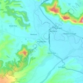
Name: Handwara topographic map, elevation, terrain.

Location: Handwara, Handwara tehsil, Kupwara District, Jammu and Kashmir, 193221, India (34.35931 74.24274 34.43931 74.32274)

Average elevation: 5,374 ft

Minimum elevation: 5,203 ft

Maximum elevation: 6,335 ft

Gear up for your next adventure:

🪶Thermal Camp Blanket - Extra warmth for cold nights
Camping Coffee Makers - Enjoy premium coffee at the summit or campsite
🗻Climbing Gear Basics - Essential gear for beginner climbers
🛠️Backpacking Tool Kit - Essential toolkit for outdoor repairs
🏕️Tent Footprint - Protect your tent base from wear

As an Amazon Associate, this site earns from qualifying purchases at no extra cost to you.