Geolocate

Parbhani topographic map

Click on the map to display elevation.

Parbhani

Parbhani is located at 19°16′N 76°47′E / 19.27°N 76.78°E / 19.27; 76.78. It has an average elevation of 347 metres.

Wikipedia (CC-BY-SA 3.0)

About this map

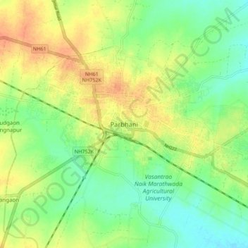
Name: Parbhani topographic map, elevation, terrain.

Location: Parbhani, Parbhani District, Maharashtra, 431400, India (19.22247 76.73180 19.30247 76.81180)

Average elevation: 1,348 ft

Minimum elevation: 1,289 ft

Maximum elevation: 1,411 ft

Gear up for your next adventure:

🛏️Cold Weather Sleeping Bag - Warm sleeping bag for cold conditions
🧼Biodegradable Camping Soap - Eco‑friendly soap for outdoor hygiene
🪶Camp Gear Gift Set - Perfect gift bundle for outdoor fans
📶Vehicle Signal Boosters - Improve reception in rural areas while driving to trailheads
🧺Microfiber Travel Towels - Compact and fast-drying towels for trail use

As an Amazon Associate, this site earns from qualifying purchases at no extra cost to you.