
Make a donation
Gear up for your next adventure:
As an Amazon Associate, this site earns from qualifying purchases at no extra cost to you.
Budingen topographic map
Click on the map to display elevation.
Make a donation
Gear up for your next adventure:
As an Amazon Associate, this site earns from qualifying purchases at no extra cost to you.
Budingen
Het dorp ligt in de provincie Vlaams-Brabant, op de grens van Hageland en Haspengouw, aan de samenvloeiing van de Grote en de Kleine Gete op 4,5 km van Zoutleeuw en op 33km van Leuven. Hoogte: 30m aan de kerk en 81m op het hoogste punt.
Make a donation
Gear up for your next adventure:
As an Amazon Associate, this site earns from qualifying purchases at no extra cost to you.
About this map
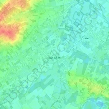
Name: Budingen topographic map, elevation, terrain.
Location: Budingen, Zoutleeuw, Leuven, Vlaams-Brabant, België (50.84612 5.04340 50.88467 5.12009)
Average elevation: 105 ft
Minimum elevation: 66 ft
Maximum elevation: 223 ft
Make a donation
Gear up for your next adventure:
As an Amazon Associate, this site earns from qualifying purchases at no extra cost to you.
Other topographic maps
Click on a map to view its topography, its elevation and its terrain.
Halle
België > Vlaams-Brabant > Leuven > Zoutleeuw
De kerk van Halle ligt op een hoogte van 46 meter. Een aantal holle wegen en kasseiwegen zijn in de omgeving te vinden. Ook loopt er, ten zuiden van het dorp, een voormalige Romeinse heerbaan, de Romeinse Steenweg.
Average elevation: 157 ft
Make a donation
Gear up for your next adventure:
As an Amazon Associate, this site earns from qualifying purchases at no extra cost to you.