
Thank you for supporting this site ❤️
Make a donation
Make a donation
Gear up for your next adventure:
As an Amazon Associate, this site earns from qualifying purchases at no extra cost to you.
Cassottana topographic map
Click on the map to display elevation.
Thank you for supporting this site ❤️
Make a donation
Make a donation
Gear up for your next adventure:
As an Amazon Associate, this site earns from qualifying purchases at no extra cost to you.
About this map
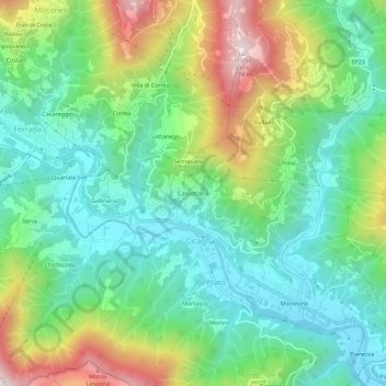
Name: Cassottana topographic map, elevation, terrain.
Location: Cassottana, Prato, Cicagna, Genova, Liguria, 16044, Italia (44.39424 9.21448 44.43424 9.25448)
Average elevation: 942 ft
Minimum elevation: 194 ft
Maximum elevation: 2,484 ft
Thank you for supporting this site ❤️
Make a donation
Make a donation
Gear up for your next adventure:
As an Amazon Associate, this site earns from qualifying purchases at no extra cost to you.