
Make a donation
Gear up for your next adventure:
As an Amazon Associate, this site earns from qualifying purchases at no extra cost to you.
Isla del Coco topographic map
Click on the map to display elevation.
Make a donation
Gear up for your next adventure:
As an Amazon Associate, this site earns from qualifying purchases at no extra cost to you.
Isla del Coco
The island is approximately rectangular in shape, measuring about 8 km × 3 km (5 mi × 2 mi) with a perimeter of around 23.3 km (14.5 mi). The landscape is mountainous and irregular; the highest point is Cerro Iglesias, at 575.5 m (1,888 ft). In spite of its mountainous character, there are flatter areas between 200–260 m (660–850 ft) in elevation in the center of the island, which are said to be a transitional stage of the geomorphological cycle of V-shaped valleys.
Make a donation
Gear up for your next adventure:
As an Amazon Associate, this site earns from qualifying purchases at no extra cost to you.
About this map
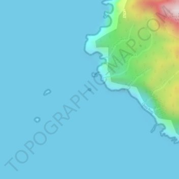
Name: Isla del Coco topographic map, elevation, terrain.
Average elevation: 213 ft
Minimum elevation: 0 ft
Maximum elevation: 1,880 ft
Make a donation
Gear up for your next adventure:
As an Amazon Associate, this site earns from qualifying purchases at no extra cost to you.