Geolocate

Sotres topographic map

Click on the map to display elevation.

About this map

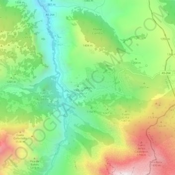
Name: Sotres topographic map, elevation, terrain.

Location: Sotres, Cabrales, Asturias, Spain (43.21308 -4.76922 43.25308 -4.72922)

Average elevation: 4,058 ft

Minimum elevation: 2,362 ft

Maximum elevation: 6,719 ft

Other topographic maps

Click on a map to view its topography, its elevation and its terrain.

Berodia

Spain > Asturias > Cabrales

Average elevation: 2,835 ft

Sotres

Spain > Asturias > Cabrales

Average elevation: 4,908 ft

San Roque

Spain > Asturias > Cabrales

The altitude is 441 m (1,447 ft) above sea level. It is 20.87 km2 (8.06 sq mi) in size with a population of 199 (INE 2011). The postal code is 33555.

Average elevation: 2,418 ft

Arenas

Spain > Asturias > Cabrales

Average elevation: 2,198 ft

Gear up for your next adventure:

🛡️Bear Spray Outdoor - Protection in bear country hikes
🎁Geography Themed Gifts - Unique gift ideas for map lovers and geography enthusiasts
🔥Plasma Lighters - Windproof lighters that work in any weather condition
🚑Emergency Bivvies - Heat-reflective sleeping bags for survival situations
🧭Pro Hiking Compasses - High-accuracy liquid-filled compasses for topographic orientation

As an Amazon Associate, this site earns from qualifying purchases at no extra cost to you.