
Thank you for supporting this site ❤️
Make a donation
Make a donation
Gear up for your next adventure:
As an Amazon Associate, this site earns from qualifying purchases at no extra cost to you.
Ussolo topographic map
Click on the map to display elevation.
Thank you for supporting this site ❤️
Make a donation
Make a donation
Gear up for your next adventure:
As an Amazon Associate, this site earns from qualifying purchases at no extra cost to you.
About this map
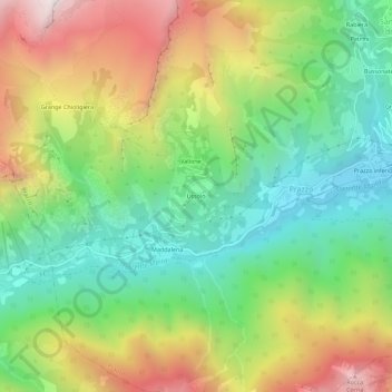
Name: Ussolo topographic map, elevation, terrain.
Location: Ussolo, Prazzo, Cuneo, Piemonte, 12028, Italia (44.46219 7.02033 44.50219 7.06033)
Average elevation: 5,092 ft
Minimum elevation: 3,278 ft
Maximum elevation: 7,835 ft
Thank you for supporting this site ❤️
Make a donation
Make a donation
Gear up for your next adventure:
As an Amazon Associate, this site earns from qualifying purchases at no extra cost to you.