
Make a donation
Gear up for your next adventure:
As an Amazon Associate, this site earns from qualifying purchases at no extra cost to you.
Tega Cay topographic map
Click on the map to display elevation.
Make a donation
Gear up for your next adventure:
As an Amazon Associate, this site earns from qualifying purchases at no extra cost to you.
About this map
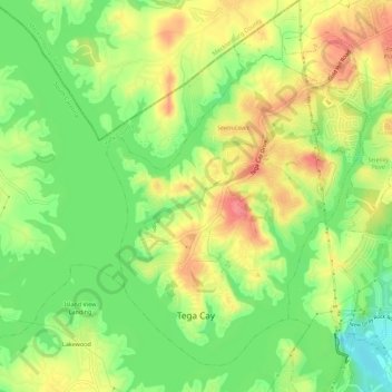
Name: Tega Cay topographic map, elevation, terrain.
Location: Tega Cay, York County, South Carolina, 29708, United States (35.01848 -81.04057 35.05788 -80.98494)
Average elevation: 604 ft
Minimum elevation: 489 ft
Maximum elevation: 722 ft
York County trails, hiking, mountain biking, running and outdoor activities
Make a donation
Gear up for your next adventure:
As an Amazon Associate, this site earns from qualifying purchases at no extra cost to you.
Other topographic maps
Click on a map to view its topography, its elevation and its terrain.
Make a donation
Gear up for your next adventure:
As an Amazon Associate, this site earns from qualifying purchases at no extra cost to you.
Boyd Hill
United States > South Carolina > York County > Rock Hill > Boyd Hill
Average elevation: 630 ft
Rock Hill
United States > South Carolina > York County > Rock Hill > Rock Hill
Average elevation: 607 ft