
Thank you for supporting this site ❤️
Make a donation
Make a donation
Gear up for your next adventure:
As an Amazon Associate, this site earns from qualifying purchases at no extra cost to you.
Montaperto topographic map
Click on the map to display elevation.
Thank you for supporting this site ❤️
Make a donation
Make a donation
Gear up for your next adventure:
As an Amazon Associate, this site earns from qualifying purchases at no extra cost to you.
About this map
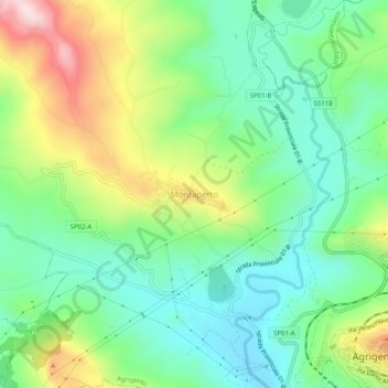
Name: Montaperto topographic map, elevation, terrain.
Location: Montaperto, Agrigento, Sicilia, 92100, Italia (37.30904 13.53112 37.34904 13.57112)
Average elevation: 581 ft
Minimum elevation: 174 ft
Maximum elevation: 1,368 ft
Thank you for supporting this site ❤️
Make a donation
Make a donation
Gear up for your next adventure:
As an Amazon Associate, this site earns from qualifying purchases at no extra cost to you.