
Thank you for supporting this site ❤️
Make a donation
Make a donation
Gear up for your next adventure:
As an Amazon Associate, this site earns from qualifying purchases at no extra cost to you.
Lezzara topographic map
Click on the map to display elevation.
Thank you for supporting this site ❤️
Make a donation
Make a donation
Gear up for your next adventure:
As an Amazon Associate, this site earns from qualifying purchases at no extra cost to you.
About this map
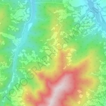
Name: Lezzara topographic map, elevation, terrain.
Location: Lezzara, Bardi, Parma, Emilia-Romagna, 43032, Italy (44.57085 9.70062 44.61085 9.74062)
Average elevation: 2,139 ft
Minimum elevation: 1,345 ft
Maximum elevation: 3,383 ft
Thank you for supporting this site ❤️
Make a donation
Make a donation
Gear up for your next adventure:
As an Amazon Associate, this site earns from qualifying purchases at no extra cost to you.