
Thank you for supporting this site ❤️
Make a donation
Make a donation
Gear up for your next adventure:
As an Amazon Associate, this site earns from qualifying purchases at no extra cost to you.
Westcliffe topographic map
Click on the map to display elevation.
Thank you for supporting this site ❤️
Make a donation
Make a donation
Gear up for your next adventure:
As an Amazon Associate, this site earns from qualifying purchases at no extra cost to you.
About this map
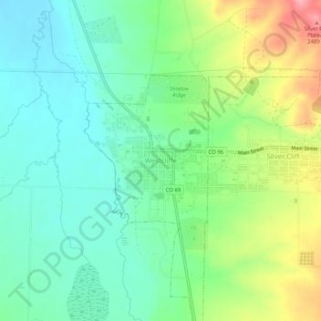
Name: Westcliffe topographic map, elevation, terrain.
Location: Westcliffe, Custer County, Colorado, 81252, United States (38.11472 -105.48584 38.15472 -105.44584)
Average elevation: 7,900 ft
Minimum elevation: 7,759 ft
Maximum elevation: 8,192 ft
Custer County trails, hiking, mountain biking, running and outdoor activities
Thank you for supporting this site ❤️
Make a donation
Make a donation
Gear up for your next adventure:
As an Amazon Associate, this site earns from qualifying purchases at no extra cost to you.