
Make a donation
Gear up for your next adventure:
As an Amazon Associate, this site earns from qualifying purchases at no extra cost to you.
Cradock topographic map
Click on the map to display elevation.
Make a donation
Gear up for your next adventure:
As an Amazon Associate, this site earns from qualifying purchases at no extra cost to you.
About this map
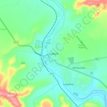
Name: Cradock topographic map, elevation, terrain.
Average elevation: 3,084 ft
Minimum elevation: 2,785 ft
Maximum elevation: 4,003 ft
Make a donation
Gear up for your next adventure:
As an Amazon Associate, this site earns from qualifying purchases at no extra cost to you.
Other topographic maps
Click on a map to view its topography, its elevation and its terrain.
Mountain Zebra National Park
South Africa > Eastern Cape > Chris Hani District Municipality > Inxuba Yethemba Local Municipality
Average elevation: 4,029 ft
Inxuba Yethemba Ward 6
South Africa > Eastern Cape > Chris Hani District Municipality > Inxuba Yethemba Local Municipality
Average elevation: 4,091 ft
Middelburg
South Africa > Eastern Cape > Chris Hani District Municipality > Inxuba Yethemba Local Municipality
Average elevation: 4,114 ft
Middelburg
South Africa > Eastern Cape > Chris Hani District Municipality > Inxuba Yethemba Local Municipality
Average elevation: 4,114 ft
Make a donation
Gear up for your next adventure:
As an Amazon Associate, this site earns from qualifying purchases at no extra cost to you.