
Make a donation
Gear up for your next adventure:
As an Amazon Associate, this site earns from qualifying purchases at no extra cost to you.
Machac topographic map
Click on the map to display elevation.
Make a donation
Gear up for your next adventure:
As an Amazon Associate, this site earns from qualifying purchases at no extra cost to you.
About this map
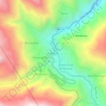
Name: Machac topographic map, elevation, terrain.
Location: Machac, Chavín de Huantar, Huari, Áncash, Perú (-9.65979 -77.22330 -9.61979 -77.18330)
Average elevation: 12,162 ft
Minimum elevation: 10,538 ft
Maximum elevation: 14,140 ft
Make a donation
Gear up for your next adventure:
As an Amazon Associate, this site earns from qualifying purchases at no extra cost to you.
Other topographic maps
Click on a map to view its topography, its elevation and its terrain.
Sitio Arqueológico de Chavín
Perú > Áncash > Chavín de Huantar > Cochas
Chavín de Huántar es un sitio arqueológico (o monumento arqueológico) ubicado en el distrito de Chavín de Huántar, provincia de Huari, departamento de Áncash, en el Perú. Declarado como Patrimonio de la Humanidad en 1985. Se ubica a 462 km al noroeste de Lima y a 86 km de Huaraz, a una elevación de…
Average elevation: 11,178 ft