
Make a donation
Gear up for your next adventure:
As an Amazon Associate, this site earns from qualifying purchases at no extra cost to you.
Torricella-Taverne topographic map
Click on the map to display elevation.
Make a donation
Gear up for your next adventure:
As an Amazon Associate, this site earns from qualifying purchases at no extra cost to you.
About this map
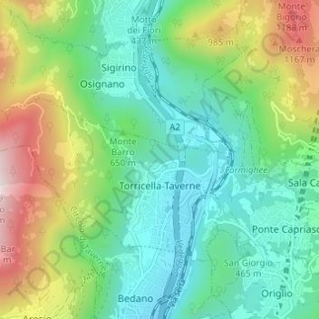
Name: Torricella-Taverne topographic map, elevation, terrain.
Average elevation: 2,129 ft
Minimum elevation: 1,063 ft
Maximum elevation: 4,603 ft
Make a donation
Gear up for your next adventure:
As an Amazon Associate, this site earns from qualifying purchases at no extra cost to you.
Other topographic maps
Click on a map to view its topography, its elevation and its terrain.
Monte Bar
Schweiz > Tessin > Bezirk Lugano > Capriasca
Trotz der relativ bescheidenen Höhe reicht die Aussicht sehr weit. An klaren Tagen sind praktisch alle Gebirgsgruppen der Alpen, die lombardische Ebene und der ligurische Apennin sichtbar.
Average elevation: 4,708 ft