Geolocate

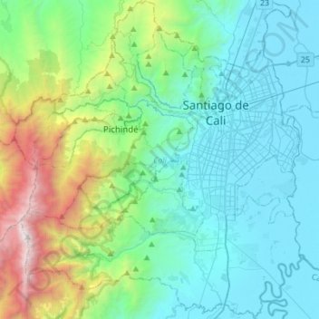
Cali topographic map

Click on the map to display elevation.

Cali

Under Köppen's climate classification, Cali features a dry-summer tropical savanna climate (Köppen climate classification: As). The Western Mountain Range rises from an average of 2,000 m (6,562 ft) above sea level in the northern part of the city to approximately 4,000 m (13,123 ft) to the south. Because of this variation in altitude, the weather in the northwest portion of the city is drier than in the southwest. The average annual precipitation varies between 900 to 1,800 mm (35 to 71 in) depending on the metropolitan zone for a citywide average of approximately 1,483 mm (58 in). Cali's average temperature is 24 °C (75 °F) with an average low temperature of 17.4 °C (63 °F) and a high of 30.5 °C (87 °F).

Wikipedia (CC-BY-SA 3.0)

About this map

Name: Cali topographic map, elevation, terrain.

Location: Cali, Sur, Valle del Cauca, RAP Pacífico, Colombia (3.27341 -76.70694 3.54858 -76.45890)

Average elevation: 4,213 ft

Minimum elevation: 3,087 ft

Maximum elevation: 10,118 ft

Other topographic maps

Click on a map to view its topography, its elevation and its terrain.

Vereda La Garza

Colombia > Valle del Cauca > Dagua > Dagua

Average elevation: 3,957 ft

San Miguel

Colombia > Valle del Cauca > Cali

Average elevation: 5,817 ft

El Coco

Colombia > Valle del Cauca > Buenaventura

Average elevation: 16 ft

Cali

Colombia > Valle del Cauca > Cali > Cali

Average elevation: 4,406 ft

Malpelo Island

Colombia > Valle del Cauca > Buenaventura

Average elevation: 30 ft

Río Anchicayá

Colombia > Valle del Cauca > Dagua

Average elevation: 1,145 ft

El Jardín

Colombia > Valle del Cauca > Cali

Average elevation: 4,610 ft

Sevilla

Colombia > Valle del Cauca > Sevilla

Average elevation: 4,767 ft

El Placer

Colombia > Valle del Cauca > Buga

Average elevation: 7,434 ft

La Paz

Colombia > Valle del Cauca > Cali

Average elevation: 5,781 ft

Alto de Anchicayá

Colombia > Valle del Cauca > Cali

Average elevation: 4,423 ft

Puerto Frazadas

Colombia > Valle del Cauca > Tuluá

Average elevation: 5,830 ft

Mayorquín

Colombia > Valle del Cauca > Buenaventura

Average elevation: 43 ft

Gear up for your next adventure:

🧭Pro Hiking Compasses - High-accuracy liquid-filled compasses for topographic orientation
🚑Emergency Bivvies - Heat-reflective sleeping bags for survival situations
🪑Portable Camp Table - Compact table for campsite meals
🧭Map Reading Tools - Tools and kits for map navigation
📌Outdoor GPS Map App - Apps and devices for digital topographic navigation

As an Amazon Associate, this site earns from qualifying purchases at no extra cost to you.