
Make a donation
Gear up for your next adventure:
As an Amazon Associate, this site earns from qualifying purchases at no extra cost to you.
Irdjen topographic map
Click on the map to display elevation.
Make a donation
Gear up for your next adventure:
As an Amazon Associate, this site earns from qualifying purchases at no extra cost to you.
Irdjen
La commune d'Irjen représente la fraction la plus basse de la confédération des Aït Iraten, en termes d'altitude, étendue depuis la vallée du Sébaou jusqu'à la crête culminante de Waylal, située à 700 m d'altitude.
Make a donation
Gear up for your next adventure:
As an Amazon Associate, this site earns from qualifying purchases at no extra cost to you.
About this map
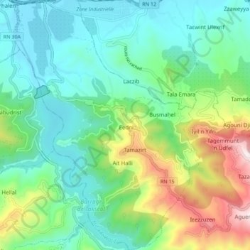
Name: Irdjen topographic map, elevation, terrain.
Location: Irdjen, Daïra Larbaa N'Aït Irathen, Tizi Ouzou, Algérie (36.63425 4.10864 36.70201 4.17169)
Average elevation: 984 ft
Minimum elevation: 243 ft
Maximum elevation: 2,943 ft
Make a donation
Gear up for your next adventure:
As an Amazon Associate, this site earns from qualifying purchases at no extra cost to you.
Other topographic maps
Click on a map to view its topography, its elevation and its terrain.
Aguemoune
Algérie > Tizi Ouzou > Daïra Larbaa N'Aït Irathen > Larbaa N'Aït Irathen
Average elevation: 2,260 ft
Make a donation
Gear up for your next adventure:
As an Amazon Associate, this site earns from qualifying purchases at no extra cost to you.