Geolocate

Duingal topographic map

Click on the map to display elevation.

About this map

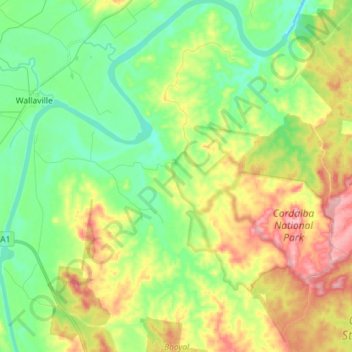
Name: Duingal topographic map, elevation, terrain.

Location: Duingal, Bundaberg Region, Queensland, Australia (-25.16651 151.98244 -25.03693 152.11826)

Average elevation: 200 ft

Minimum elevation: 20 ft

Maximum elevation: 499 ft

Other topographic maps

Click on a map to view its topography, its elevation and its terrain.

Gin Gin

Australia > Queensland > Bundaberg Region > Gin Gin

Average elevation: 240 ft

Isis River

Australia > Queensland > Bundaberg Region > Buxton

Average elevation: 39 ft

Burrum River

Australia > Queensland > Bundaberg Region > Buxton

Average elevation: 66 ft

Woodgate Beach

Australia > Queensland > Bundaberg Region

Average elevation: 10 ft

Bundaberg

Australia > Queensland > Bundaberg Region

Average elevation: 59 ft

Bundaberg

Australia > Queensland > Bundaberg Region

Average elevation: 59 ft

Gear up for your next adventure:

🔥Camping Stove - Portable stove for camping and backcountry cooking
🔭Telescopic Hiking Pole - Adjustable pole for hiking stability
🌡️Handheld Weather Meters - Measure wind, temp, and pressure for safe mountain travel
🎒Outdoor Daypacks - Lightweight backpacks designed for carrying maps and essential gear
🛌Ultralight Sleeping Bags - Compact down bags for cold nights in the wilderness

As an Amazon Associate, this site earns from qualifying purchases at no extra cost to you.