
Make a donation
Gear up for your next adventure:
As an Amazon Associate, this site earns from qualifying purchases at no extra cost to you.
Hatch topographic map
Click on the map to display elevation.
Make a donation
Gear up for your next adventure:
As an Amazon Associate, this site earns from qualifying purchases at no extra cost to you.
About this map
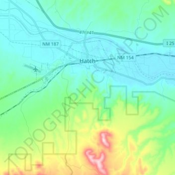
Name: Hatch topographic map, elevation, terrain.
Location: Hatch, Doña Ana County, New Mexico, United States (32.61736 -107.26541 32.67834 -107.13158)
Average elevation: 4,324 ft
Minimum elevation: 4,022 ft
Maximum elevation: 5,417 ft
Doña Ana County trails, hiking, mountain biking, running and outdoor activities
Make a donation
Gear up for your next adventure:
As an Amazon Associate, this site earns from qualifying purchases at no extra cost to you.
Other topographic maps
Click on a map to view its topography, its elevation and its terrain.
White Sands Missile Range
United States > New Mexico > Doña Ana County > White Sands
Average elevation: 4,285 ft
White Sands Missile Range
United States > New Mexico > Doña Ana County > White Sands
Average elevation: 4,285 ft
Make a donation
Gear up for your next adventure:
As an Amazon Associate, this site earns from qualifying purchases at no extra cost to you.