Geolocate

Denton topographic map

Click on the map to display elevation.

About this map

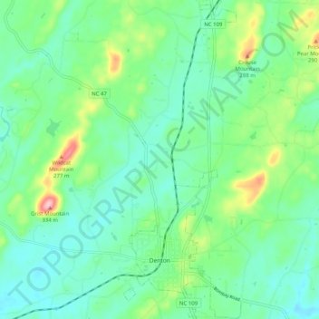
Name: Denton topographic map, elevation, terrain.

Location: Denton, Davidson County, North Carolina, United States (35.61830 -80.12736 35.70025 -80.09003)

Average elevation: 712 ft

Minimum elevation: 577 ft

Maximum elevation: 1,093 ft

Davidson County trails, hiking, mountain biking, running and outdoor activities

Other topographic maps

Click on a map to view its topography, its elevation and its terrain.

Linwood

United States > North Carolina > Davidson County

Average elevation: 679 ft

Lakeview

United States > North Carolina > Davidson County

Average elevation: 696 ft

Jersey

United States > North Carolina > Davidson County

Average elevation: 663 ft

Arnold

United States > North Carolina > Davidson County > Arnold

Average elevation: 814 ft

Gear up for your next adventure:

🧣Merino Neck Gaiters - Multi-functional headwear for wind and sun protection
💧Water Purification System - Clean water on the trail with reliable purifiers
🧷Carabiner Set - Durable clips for gear attachment
🧺Microfiber Travel Towels - Compact and fast-drying towels for trail use
🎒Outdoor Daypacks - Lightweight backpacks designed for carrying maps and essential gear

As an Amazon Associate, this site earns from qualifying purchases at no extra cost to you.