Geolocate

Perry Lake topographic map

Click on the map to display elevation.

About this map

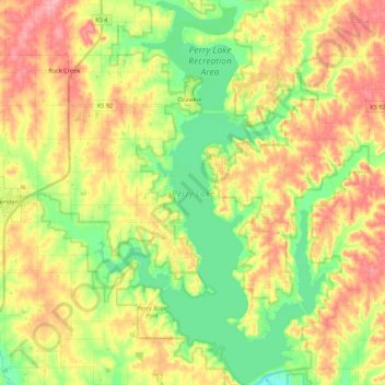
Name: Perry Lake topographic map, elevation, terrain.

Location: Perry Lake, Jefferson County, Kansas, United States (39.10889 -95.52089 39.27621 -95.39029)

Average elevation: 994 ft

Minimum elevation: 837 ft

Maximum elevation: 1,168 ft

Other topographic maps

Click on a map to view its topography, its elevation and its terrain.

Boyle

United States > Kansas > Jefferson County

Average elevation: 1,119 ft

Gear up for your next adventure:

🦟Ultrasonic Repellers - Create a bug-free zone at your camp or rest stop
🔪Outdoor Multitools - Essential survival tools for gear repair and field use
❄️Traction Cleats - Prevent slips on icy trails during winter hikes
🛶Inflatable Kayak - Portable kayak for rivers, lakes, and expeditions
🦶Hiking Gaiters - Keep debris and water out of your boots

As an Amazon Associate, this site earns from qualifying purchases at no extra cost to you.