
Make a donation
Gear up for your next adventure:
As an Amazon Associate, this site earns from qualifying purchases at no extra cost to you.
Lützen topographic map
Click on the map to display elevation.
Make a donation
Gear up for your next adventure:
As an Amazon Associate, this site earns from qualifying purchases at no extra cost to you.
About this map
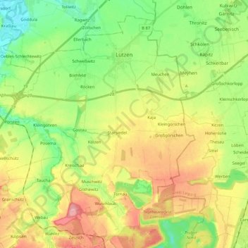
Name: Lützen topographic map, elevation, terrain.
Location: Lützen, Burgenlandkreis, Saxony-Anhalt, 06686, Germany (51.16610 11.99926 51.27874 12.20480)
Average elevation: 443 ft
Minimum elevation: 292 ft
Maximum elevation: 646 ft
Make a donation
Gear up for your next adventure:
As an Amazon Associate, this site earns from qualifying purchases at no extra cost to you.
Other topographic maps
Click on a map to view its topography, its elevation and its terrain.
Tromsdorf
Germany > Saxony-Anhalt > Burgenlandkreis > Eckartsberga > Tromsdorf
Average elevation: 640 ft
Plößnitz
Germany > Saxony-Anhalt > Burgenlandkreis > Laucha an der Unstrut > Plößnitz
Average elevation: 676 ft