Geolocate

Great Dunmow topographic map

Click on the map to display elevation.

About this map

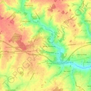
Name: Great Dunmow topographic map, elevation, terrain.

Location: Great Dunmow, Uttlesford, Essex, England, United Kingdom (51.83769 0.32331 51.90903 0.40488)

Average elevation: 266 ft

Minimum elevation: 144 ft

Maximum elevation: 354 ft

Gear up for your next adventure:

🕶️Glacier Sunglasses - Side shields to protect eyes from high-altitude snow glare
🪄Magnetic Compass - Accurate compass for navigation
📻Weather Alert Radios - Stay informed of storm risks while off-the-grid
📶Satellite Messenger - Communication device off‑grid
❄️Traction Cleats - Prevent slips on icy trails during winter hikes

As an Amazon Associate, this site earns from qualifying purchases at no extra cost to you.