
Make a donation
Gear up for your next adventure:
As an Amazon Associate, this site earns from qualifying purchases at no extra cost to you.
Ellershausen topographic map
Click on the map to display elevation.
Make a donation
Gear up for your next adventure:
As an Amazon Associate, this site earns from qualifying purchases at no extra cost to you.
About this map
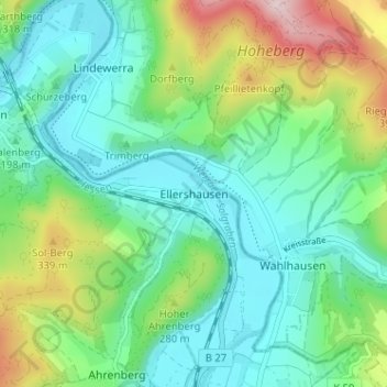
Name: Ellershausen topographic map, elevation, terrain.
Average elevation: 748 ft
Minimum elevation: 440 ft
Maximum elevation: 1,552 ft
Make a donation
Gear up for your next adventure:
As an Amazon Associate, this site earns from qualifying purchases at no extra cost to you.
Other topographic maps
Click on a map to view its topography, its elevation and its terrain.
Dudenrode
Deutschland > Hessen > Werra-Meißner-Kreis > Bad Sooden-Allendorf
Dudenrode liegt im Geo-Naturpark Frau-Holle-Land (Werratal.Meißner.Kaufunger Wald). Es befindet sich 7,3 km westlich der Kernstadt von Bad Sooden-Allendorf auf 330 m Höhe. Nachbarorte sind der Bad Sooden-Allendorfer Stadtteil Hilgershausen im Nordosten, der Berkataler Ortsteil Frankenhain im Südosten und…
Average elevation: 1,371 ft
Hessische Schweiz bei Meinhard
Deutschland > Hessen > Werra-Meißner-Kreis > Bad Sooden-Allendorf > Hitzelrode
Average elevation: 1,394 ft
Kammerbach
Deutschland > Hessen > Werra-Meißner-Kreis > Bad Sooden-Allendorf
Average elevation: 1,086 ft
Oberrieden
Deutschland > Hessen > Werra-Meißner-Kreis > Bad Sooden-Allendorf
Oberrieden liegt in der Nähe des Dreiländerecks Hessen–Thüringen–Niedersachsen nahe der Mündung des Oberrieder Bachs in die Werra. Südlich des Dorfs befindet sich das Soodener Bergland (482,4 m) mit daran anschließendem Hohem Meißner (751,2 m), und nordöstlich der Schürzeberg (213,9 m), die wie…
Average elevation: 768 ft
Make a donation
Gear up for your next adventure:
As an Amazon Associate, this site earns from qualifying purchases at no extra cost to you.