
Make a donation
Gear up for your next adventure:
As an Amazon Associate, this site earns from qualifying purchases at no extra cost to you.
Pine Mountain topographic map
Click on the map to display elevation.
Make a donation
Gear up for your next adventure:
As an Amazon Associate, this site earns from qualifying purchases at no extra cost to you.
About this map
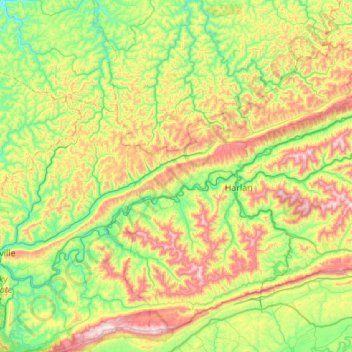
Name: Pine Mountain topographic map, elevation, terrain.
Location: Pine Mountain, Harlan County, Kentucky, United States (36.75770 -83.68539 36.95788 -83.13993)
Average elevation: 1,759 ft
Minimum elevation: 876 ft
Maximum elevation: 3,442 ft
Harlan County trails, hiking, mountain biking, running and outdoor activities
Make a donation
Gear up for your next adventure:
As an Amazon Associate, this site earns from qualifying purchases at no extra cost to you.
Other topographic maps
Click on a map to view its topography, its elevation and its terrain.
Make a donation
Gear up for your next adventure:
As an Amazon Associate, this site earns from qualifying purchases at no extra cost to you.
Make a donation
Gear up for your next adventure:
As an Amazon Associate, this site earns from qualifying purchases at no extra cost to you.
Make a donation
Gear up for your next adventure:
As an Amazon Associate, this site earns from qualifying purchases at no extra cost to you.
Make a donation
Gear up for your next adventure:
As an Amazon Associate, this site earns from qualifying purchases at no extra cost to you.
Harlan
United States > Kentucky > Harlan County
Harlan is located in west-central Harlan County at 36°50′29″N 83°19′12″W / 36.84139°N 83.32000°W / 36.84139; -83.32000 (36.841487, -83.320066), at the junction of the Clover Fork and Martin's Fork rivers. The Clover Fork continues north 1.5 miles (2.4 km) to join the Poor Fork, forming the…
Average elevation: 1,617 ft
Make a donation
Gear up for your next adventure:
As an Amazon Associate, this site earns from qualifying purchases at no extra cost to you.
Make a donation
Gear up for your next adventure:
As an Amazon Associate, this site earns from qualifying purchases at no extra cost to you.
Make a donation
Gear up for your next adventure:
As an Amazon Associate, this site earns from qualifying purchases at no extra cost to you.
Cumberland
United States > Kentucky > Harlan County
Cumberland is located in northeastern Harlan County at 36°58′37″N 82°59′15″W / 36.97694°N 82.98750°W / 36.97694; -82.98750 (36.977016, -82.987434) in the valley of the Poor Fork of the Cumberland River, where it is joined by Looney Creek from the southeast and Cloverlick Creek from the…
Average elevation: 1,939 ft
Harlan
United States > Kentucky > Harlan County > Harlan > Harlan
Harlan is located in west-central Harlan County at 36°50′29″N 83°19′12″W / 36.84139°N 83.32000°W / 36.84139; -83.32000 (36.841487, -83.320066), at the junction of the Clover Fork and Martin's Fork rivers. The Clover Fork continues north 1.5 miles (2.4 km) to join the Poor Fork, forming the…
Average elevation: 1,680 ft
Make a donation
Gear up for your next adventure:
As an Amazon Associate, this site earns from qualifying purchases at no extra cost to you.
Lynch
United States > Kentucky > Harlan County
Lynch is located in eastern Harlan County at 36°57′54″N 82°55′00″W / 36.965133°N 82.916569°W / 36.965133; -82.916569 (36.965133, -82.916569), in the valley of Looney Creek. Lynch is the nearest city to Kentucky's highest point, Black Mountain (4,145 ft or 1,263 m). Sitting at an elevation…
Average elevation: 2,526 ft