
Tolga topographic map
Interactive map
Click on the map to display elevation.
About this map
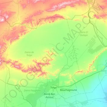
Name: Tolga topographic map, elevation, terrain.
Location: Tolga, Daïra Tolga, Biskra, Algérie (34.67965 4.92519 35.09771 5.52892)
Average elevation: 889 ft
Minimum elevation: 164 ft
Maximum elevation: 2,595 ft
Other topographic maps
Click on a map to view its topography, its elevation and its terrain.
Lichana
Algérie > Biskra > Daïra Tolga
Lichana, Daïra Tolga, Biskra, 07009, Algérie
Average elevation: 545 ft