
San Vicente del Caguán topographic map
Interactive map
Click on the map to display elevation.
About this map
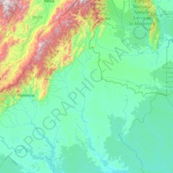
Name: San Vicente del Caguán topographic map, elevation, terrain.
Location: San Vicente del Caguán, Caquetá, 182010, Colombia (0.53623 -75.15494 2.93319 -73.24143)
Average elevation: 1,919 ft
Minimum elevation: 564 ft
Maximum elevation: 12,411 ft
Other topographic maps
Click on a map to view its topography, its elevation and its terrain.
Chiribiquete (Macizo Central)
Chiribiquete (Macizo Central), Solano, Caquetá, Colombia
Average elevation: 951 ft
Azabache
Colombia > Caquetá > Belén de los Andaquíes
Azabache, Belén de los Andaquíes, Caquetá, Colombia
Average elevation: 830 ft
Puerto Gaitan
Colombia > Caquetá > Puerto Gaitan
Puerto Gaitan, La Montañita, Caquetá, Colombia
Average elevation: 817 ft
San Vicente del Caguán
Colombia > Caquetá > San Vicente del Caguán > San Vicente del Caguán
San Vicente del Caguán, Caquetá, 182010, Colombia
Average elevation: 906 ft