
Thank you for supporting this site ❤️
Make a donation
Make a donation
Gear up for your next adventure:
As an Amazon Associate, this site earns from qualifying purchases at no extra cost to you.
Pine Cobble topographic map
Click on the map to display elevation.
Thank you for supporting this site ❤️
Make a donation
Make a donation
Gear up for your next adventure:
As an Amazon Associate, this site earns from qualifying purchases at no extra cost to you.
About this map
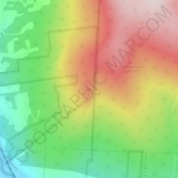
Name: Pine Cobble topographic map, elevation, terrain.
Average elevation: 1,398 ft
Minimum elevation: 591 ft
Maximum elevation: 2,287 ft
Thank you for supporting this site ❤️
Make a donation
Make a donation
Gear up for your next adventure:
As an Amazon Associate, this site earns from qualifying purchases at no extra cost to you.
Other topographic maps
Click on a map to view its topography, its elevation and its terrain.
Clover Hill Farm Conservation Area
United States > Massachusetts > Berkshire County > Williamstown > Meadowvale
Average elevation: 712 ft
Mountain Meadow Preserve
United States > Massachusetts > Berkshire County > Williamstown
Average elevation: 876 ft